

A line of strong-to-severe weather has arrived in Kansas City. The metro remains under a tornado watch until 4 a.m. on Tuesday morning. ALERT DAY LIVE UPDATES: 11:47 p.m. — The National Weather Service has allowed the tornado warning for Jackson County, Missouri to expire. It is continuing the tornado warning for Lafayette and Ray counties. 11:44 p.m. — The Cass County Sheriff’s Office is reporting a funnel cloud south of Crieghton. 11:43 p.m. — A new tornado warning has been issued for Johnson County, Missouri. 11:40 p.m. — Both tornado warnings are for radar-indicated storms. There has been no confirmed tornado yet. 11:35 p.m. — A tornado warning has been issued by the National Weather Service in Pleasant Hill for southeastern Cass County, northwestern Henry County, northeastern Bates County, and south central Johnson County in west central Missouri. It’s in place until midnight.11:31 p.m. — A Tornado Warning has been issued by the National Weather Service in Pleasant Hill for areas including south central Ray County, west central Lafayette County, and east central Jackson County in west central Missouri. It’s in place until midnight. 11:26 p.m. — The National Weather Service has allowed the tornado warning to expire. 11:19 p.m. — The National Weather Service has allowed severe thunderstorm warnings on the Kansas side to expire. 11:13 p.m. — The tornado warning for northeastern Platte County has been cancelled.11:00 p.m. — A tornado warning has been issued by the National Weather Service for parts of northwestern Missouri, including Clinton County, Northwestern Clay County, and Northeastern Platte County. The warning is in place until 11:30 p.m.10:33 p.m. — KMBC Chief Meteorologist Bryan Busby has an update forecast for the rest of the night and Tuesday: 10:17 p.m. — The National Weather Service is monitoring a “couple of areas or rotation,” one south of Tonganoxie and another southeast of Ottawa, Kansas. No warnings have been issued yet. 10:16 p.m. — Severe thunderstorms have arrived in the immediate metro area. The National Weather Service has issued a severe thunderstorm warning for Wyandotte, Leavenworth, and Johnson counties in Kansas, and Platte County in Missouri. This warning is in effect until 11:15 p.m. The storms could bring 60 mph wind gusts, penny size hail and possible damage to roofs, siding, and trees.9:12 p.m. KMBC First Alert meteorologist Neville Miller discusses the tornado watch and the biggest threats the metro could see tonight. Damage winds and hail are the most likely threats, but a brief spin-up tornado cannot be ruled out: 9:09 p.m. — KMBC First Alert meteorologist Nick Bender is tracking the possibility of severe weather in Kansas and Missouri: 8:41 p.m. — The Kansas City metro area is now under a tornado watch until 4 a.m. All of the counties in the metro area are included. 8:16 p.m. — Multiple lines of severe weather have developed in Kansas. The National Weather Service says conditions still exist for severe weather in the metro area, with an ongoing across northeast Kansas into southeast Nebraska, with damaging winds and tornadoes being possible. There’s also potential for hail.FORECAST: Tonight’s severe weather outbreak, which starts in the central plains, will have several types of severe weather elements with different intensities. The large, long-tracked tornadoes we typically think of when we think about severe weather are most likely between Oklahoma City, and Wichita, Kansas. Those could be accompanied by gigantic hail: 2-4 inches in diameter. However, tornadoes are possible anywhere in the outlook area, so no one should let their guard down. The Kansas City area has the potential for damaging straight-line winds along with large hail. We cannot rule out the potential of fast-developing tornadoes along the leading edge of the line of thunderstorms. Some extra vigilance is warranted after sunset. The most likely scenario for the KMBC viewing area is a long line of storms capable of 70-80 mph straight-line winds, a brief tornado spin-up within that line and small hail. The storms could be in our viewing area by 8 p.m. and exit the viewing area by 1 a.m.Here are some terms you may hear us use during this event:Long-track tornadoes: These are generally on the ground for more than 15 milesSupercells: Large towering, rotating storms that usually stand alone. It’s from these types of storms that we get large tornadoes and very large hail.Wall cloud: A rotating lowering cloud underneath that supercell storm from which the tornado would form. Shelf cloud: A long cloud that stretches across the horizon. It does not contain severe weather, but it is an indication the squall line is approaching.Squall line: A bowing line of storms capable of very strong wind at the apex, or point, of the bow.QLCS: Quasi-Linear Convective System: A series of squall lines, lined up from north to south. Damaging straight-line wind is the primary hazard with these systems, but they can also cause brief tornado spin-ups. Drier weather will prevail for the remainder of the upcoming week, with highs in the upper 70s to around 80.Thunderstorms and severe weather in late April are nothing new to Midwesterners. We prepare the same way year in and year out when severe weather threatens by checking the forecast often for updates, reviewing our severe weather safety plan, and having multiple ways to receive weather alerts. What makes the Monday night storms concerning is the fact that they’re happening overnight, in cover of darkness. It’s important that you make sure whatever methods you are using for your weather alerts have the ability to wake you.
A line of strong-to-severe weather has arrived in Kansas City.
The metro remains under a tornado watch until 4 a.m. on Tuesday morning.
ALERT DAY LIVE UPDATES:
11:47 p.m. — The National Weather Service has allowed the tornado warning for Jackson County, Missouri to expire. It is continuing the tornado warning for Lafayette and Ray counties.
11:44 p.m. — The Cass County Sheriff’s Office is reporting a funnel cloud south of Crieghton.
11:43 p.m. — A new tornado warning has been issued for Johnson County, Missouri.
11:40 p.m. — Both tornado warnings are for radar-indicated storms. There has been no confirmed tornado yet.
11:35 p.m. — A tornado warning has been issued by the National Weather Service in Pleasant Hill for southeastern Cass County, northwestern Henry County, northeastern Bates County, and south central Johnson County in west central Missouri. It’s in place until midnight.
11:31 p.m. — A Tornado Warning has been issued by the National Weather Service in Pleasant Hill for areas including south central Ray County, west central Lafayette County, and east central Jackson County in west central Missouri. It’s in place until midnight.
11:26 p.m. — The National Weather Service has allowed the tornado warning to expire.
11:19 p.m. — The National Weather Service has allowed severe thunderstorm warnings on the Kansas side to expire.
11:13 p.m. — The tornado warning for northeastern Platte County has been cancelled.
11:00 p.m. — A tornado warning has been issued by the National Weather Service for parts of northwestern Missouri, including Clinton County, Northwestern Clay County, and Northeastern Platte County. The warning is in place until 11:30 p.m.
10:33 p.m. — KMBC Chief Meteorologist Bryan Busby has an update forecast for the rest of the night and Tuesday:
10:17 p.m. — The National Weather Service is monitoring a “couple of areas or rotation,” one south of Tonganoxie and another southeast of Ottawa, Kansas. No warnings have been issued yet.
10:16 p.m. — Severe thunderstorms have arrived in the immediate metro area. The National Weather Service has issued a severe thunderstorm warning for Wyandotte, Leavenworth, and Johnson counties in Kansas, and Platte County in Missouri. This warning is in effect until 11:15 p.m. The storms could bring 60 mph wind gusts, penny size hail and possible damage to roofs, siding, and trees.
9:12 p.m. KMBC First Alert meteorologist Neville Miller discusses the tornado watch and the biggest threats the metro could see tonight. Damage winds and hail are the most likely threats, but a brief spin-up tornado cannot be ruled out:
9:09 p.m. — KMBC First Alert meteorologist Nick Bender is tracking the possibility of severe weather in Kansas and Missouri:
8:41 p.m. — The Kansas City metro area is now under a tornado watch until 4 a.m. All of the counties in the metro area are included.
8:16 p.m. — Multiple lines of severe weather have developed in Kansas.
The National Weather Service says conditions still exist for severe weather in the metro area, with an ongoing across northeast Kansas into southeast Nebraska, with damaging winds and tornadoes being possible.
There’s also potential for hail.
FORECAST:
Tonight’s severe weather outbreak, which starts in the central plains, will have several types of severe weather elements with different intensities.
The large, long-tracked tornadoes we typically think of when we think about severe weather are most likely between Oklahoma City, and Wichita, Kansas. Those could be accompanied by gigantic hail: 2-4 inches in diameter.
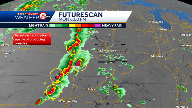
However, tornadoes are possible anywhere in the outlook area, so no one should let their guard down.
[Click here to download the KMBC 9 News app for weather on the go]
The Kansas City area has the potential for damaging straight-line winds along with large hail.
We cannot rule out the potential of fast-developing tornadoes along the leading edge of the line of thunderstorms. Some extra vigilance is warranted after sunset.
This content is imported from Twitter.
You may be able to find the same content in another format, or you may be able to find more information, at their web site.
The most likely scenario for the KMBC viewing area is a long line of storms capable of 70-80 mph straight-line winds, a brief tornado spin-up within that line and small hail. The storms could be in our viewing area by 8 p.m. and exit the viewing area by 1 a.m.
Here are some terms you may hear us use during this event:
Long-track tornadoes: These are generally on the ground for more than 15 miles
Supercells: Large towering, rotating storms that usually stand alone. It’s from these types of storms that we get large tornadoes and very large hail.
Wall cloud: A rotating lowering cloud underneath that supercell storm from which the tornado would form.
Shelf cloud: A long cloud that stretches across the horizon. It does not contain severe weather, but it is an indication the squall line is approaching.
Squall line: A bowing line of storms capable of very strong wind at the apex, or point, of the bow.

QLCS: Quasi-Linear Convective System: A series of squall lines, lined up from north to south. Damaging straight-line wind is the primary hazard with these systems, but they can also cause brief tornado spin-ups.
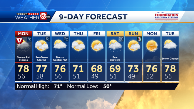
Drier weather will prevail for the remainder of the upcoming week, with highs in the upper 70s to around 80.
Thunderstorms and severe weather in late April are nothing new to Midwesterners.
We prepare the same way year in and year out when severe weather threatens by checking the forecast often for updates, reviewing our severe weather safety plan, and having multiple ways to receive weather alerts.
What makes the Monday night storms concerning is the fact that they’re happening overnight, in cover of darkness. It’s important that you make sure whatever methods you are using for your weather alerts have the ability to wake you.
Discover more from PressNewsAgency
Subscribe to get the latest posts sent to your email.