
Parts of the north and west of NSW were inundated yesterday as heavy falls hung over eastern Australia.
Flood warnings were issued for the Orara River late last night and the Tweed River just after 1am, with minor flooding possible at Tumbulgum and Glenreagh.
The Bureau of Meteorology said the heavy rainfall overnight would begin to move away from the mainland during today and should be clear by tonight.
NSW Emergency Services Minister Steph Cooke said the deluge was the start of a flooding season expected to stretch through spring and summer as flood-exhausted communities in the north and west of the state face renewed warnings.
She said even after the rain stopped, the flood risk would continue.
“We’re facing challenges on multiple fronts with prolonged flooding through the west and north-west of NSW, renewed river rises in the Central West and southern parts of NSW,” she said.
“Now communities in the Northern Rivers, Mid North Coast and North Coast who have been made flood weary over the past several months are facing an uncertain couple of days with weather conditions worsening.
“We are at the start of a very long season we expect, this is the third consecutive La Nina, and as we have seen all year our catchments and landscapes are highly saturated.
“This increases the risk of flash flooding and water coming up very very quickly and catching people unawares.”

Flash flooding from Queensland to NSW Central Coast
Yesterday, meteorologist Jane Golding said more than 100 millimetres had fallen on the NSW North Coast. Inland NSW was expected to be inundated for days.
In the state’s west, major flooding was expected at Wee Waa, Warren, and Euabalong.
Some towns are already facing being cut off by rising floodwaters, like Calala, near Tamworth, where just one road in and out of the suburb remains.
Further north, flash flooding was expected between the Queensland border to the Central Coast.
The Northern Rivers may see flash flooding for the fourth time this year.
“We’re expecting areas to see 24-hour totals of above 100mm but we’re going to see some bullseyes in there that are higher than that, and those bullseyes are where we will see flash flooding,” Golding said.
“That’s enough rain to cause the rivers to start rising, roads ponding, and dangerous driving conditions. The ground is so saturated across all of NSW with the gusty winds around at the moment we can expect trees down as well.”
The Mid North Coast is one of the key areas of concern. More than 100mm fell between Grafton to Coffs Harbour in 24 hours.
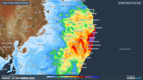
Some parts of the Mid North Coast saw 180mm in 24 hours.
“Flooding is a key concern and is expected to be a key concern for several months,” she said.
Cars submerged and almost 50 flood rescues in NSW
Images emerged of cars completely submerged in water in NSW’s Mid North Coast and north-west as authorities pleaded with residents not to drive across flooded roads.
One of the images taken in Warren, north-west of Dubbo, showed the top of the car barely visible above water level.
“No this is not a submarine, it’s a car floating away in flood water on the outskirts of Warren,” the NSW State Emergency Service said.
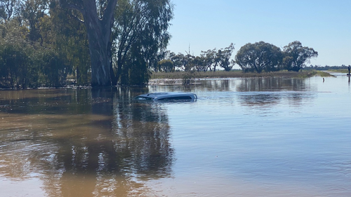
“The driver started to drive through the flood water when their car got pushed off the road and almost completely submerged.
“No matter how shallow the flood water looks, you never know how fast flowing it is or how quickly it can rise. It’s not worth the risk, turn around and find another route.”
NSW SES Commissioner Carlene York said there had been 49 rescues and more than 500 calls for help.
“It is important if people see water across the road they do not drive into the floodwaters and find an alternate route,” she said.
Emergency services had to use a boat to rescue a man trapped by floodwater in Boggabri, also in NSW’s north-west.
Police said the man’s vehicle became submerged approximately 5km east of the Kamilaroi Highway around noon yesterday.
Authorities tried to reach the 22-year-old man but said they were “unable to get to the location due to the flood levels”, forcing SES crews to take to the roads in a boat.
“A short time later, the man was rescued from the roof of his vehicle,” police said in a statement.
“The man was uninjured and did not require medical treatment.”
The man was issued with an infringement notice for the offence of disobey road access sign, which carries a $283 fine and two demerit points.

Endangered critters right at home in late winter wonderland
