

Satellite image of Tropical Storm Francine on Sept. 10 as it intensified in the Gulf of Mexico. Image: NOAA
Storm Francine intensified into a hurricane Tuesday evening as it churned from the western Gulf of Mexico toward coastal Louisiana, per the National Hurricane Center.
Threat level: Hurricane, storm surge and tropical storm watches and warnings are in effect from westernmost Louisiana to coastal Mississippi.
- Hurricane warnings are in force, indicating hurricane conditions are expected within the warning region during the next 36 hours, for much of the Louisiana coastline.
- A tropical storm warning is in effect for the New Orleans metro area, with storm surge warnings spanning from High Island, Texas to the Mississippi-Alabama border.
- A hurricane watch is also in effect for New Orleans, given an eastward trend in the track forecast on Tuesday. “Hurricane conditions are
possible in the Hurricane Watch area Wednesday and Wednesday night,” the Hurricane Center stated. - With New Orleans forecast to be on the eastern, or stronger side of the storm, there is an increasing risk of damaging winds, heavy rains and tornadoes that are often associated with landfalling tropical cyclones.
The latest: The Category 1 Hurricane Francine was packing maximum sustained winds of 75 mph about 295 miles southwest of Morgan City, La., per a 10pm ET National Hurricane Center advisory.
State of play: The National Hurricane Center predicts Francine will come ashore to the west of New Orleans with maximum sustained winds of 90 on Wednesday afternoon or night.
- Heavy rains from the system could cause significant flash flooding from the coast to well inland, especially since several inches of rain fell across this region last week. The NHC is forecasting storm total rainfall amounts to range from 4 to 8 inches, with local totals up to a foot.


Zoom in: The Weather Prediction Center has placed much of Louisiana, including New Orleans, and southwestern Mississippi in a “moderate risk” for inland flooding as the storm plows inland.
- While steady to potentially rapid intensification is forecast on Tuesday into Tuesday night, strong winds aloft and some dry air may cause the intensification to stop or cause it to weaken slightly near or especially immediately after landfall, the Hurricane Center stated.
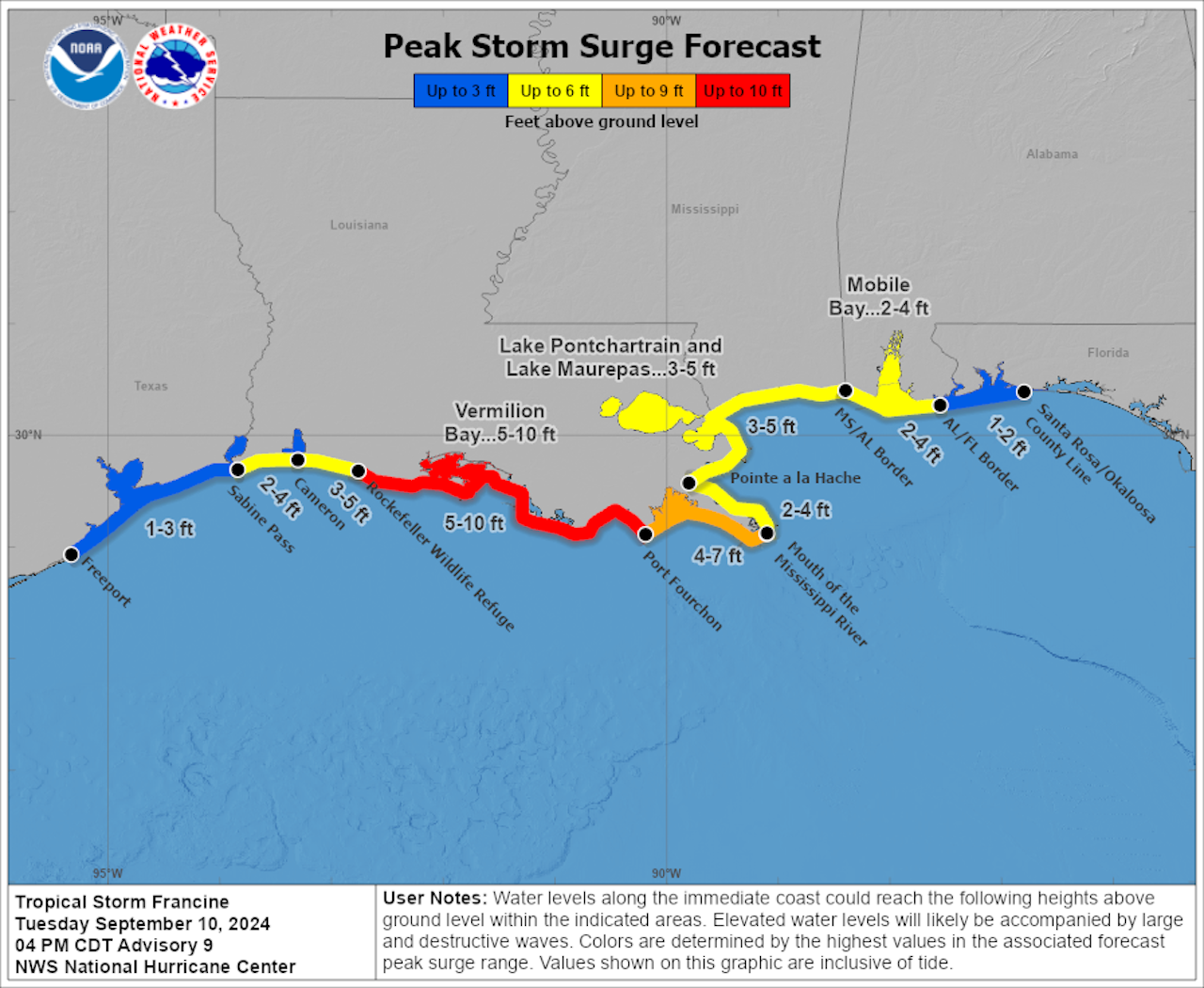
- Tropical Storm Francine is forecast to hit a part of the Gulf Coast vulnerable to storm surge flooding. Predictions call for 5 to 10 feet of water above normally dry ground along the central Louisiana coast, if the peak surge hits a high tide.
- Lake Pontchartrain, which borders New Orleans, is forecast to see a 3-to-5-foot surge on top of normally dry land if the storm hits at high tide, based on its predicted path as of Tuesday at 5pm.
Between the lines: The Louisiana coast faces dual threats from rising sea levels due to climate change along with sinking land, which makes it especially prone to storm surge flooding.
The big picture: Francine ends the prolonged quiet period that the Atlantic Ocean Basin has been in since mid-August when Hurricane Ernesto dissipated on Aug. 20.
The bottom line: Gulf Coastal residents need to make preparations today if they are in its predicted path, as high winds from then-Hurricane Francine may arrive in Louisiana as soon as early Wednesday morning.
More from Axios:
Editor’s note: This a breaking news story. Please check back for updates.
Discover more from PressNewsAgency
Subscribe to get the latest posts sent to your email.