
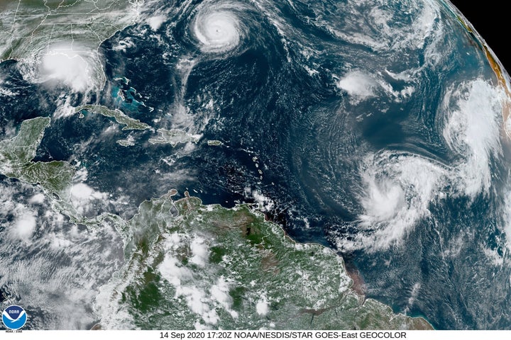
WAVELAND, Miss. (AP) — Hurricane Sally, a plodding storm with winds of 85 mph (137 kph), crept toward the northern Gulf Coast early Tuesday as forecasters warned of potentially deadly storm surges and flash floods with up to 2 feet (.61 meters) of rain and the possibility of tornadoes.
Forecasters stressed “significant†uncertainty as to where the storm’s eye would make landfall. But they kept nudging the predicted track eastward, easing fears in New Orleans, which was once in Sally’s crosshairs.
By early Tuesday, hurricane warnings stretched from the mouth of the Pearl River at the Louisiana-Mississippi line to Navarre, Florida, and forecasters said Sally should reach land near the Alabama-Mississippi state line by late Tuesday or early Wednesday.Â
Stacy Stewart, a senior specialist with the National Hurricane Center, said Tuesday that people should continue to take the storm seriously since “devastating†rainfall is expected in large areas. People could drown in the flooding, he said.
“This is going to be historic flooding along with the historic rainfall,†Stewart said. “If people live near rivers, small streams and creeks, they need to evacuate and go somewhere else.â€
The storm was moving at only 2 mph (4 kph) before dawn on Tuesday, centered about 115 miles (185 kilometers) south-southeast of Biloxi, Mississippi, and 60 miles (97 kilometers) east-southeast of the mouth of the Mississippi River.
Forecasters expect Sally to turn northward Tuesday afternoon, moving near the coast of southeastern Louisiana later in the day, and then travel slowly north-northeastward through Wednesday, remaining a Category 1 hurricane, with top winds of 85 mph (137 kph), until it comes ashore.
After making landfall, Sally was forecast to cause flash floods and minor to moderate river flooding across inland portions of Mississippi, Alabama, northern Georgia and the western Carolinas through the rest of the week.
Florida Gov. Ron DeSantis declared an emergency in the Panhandle’s westernmost counties, which were being pummeled by rain from Sally’s outer bands early Tuesday. The threat of heavy rain and storm surge was exacerbated by the storm’s slow movement.
President Donald Trump issued emergency declarations for parts of Louisiana, Mississippi and Alabama on Monday, and tweeted that residents should listen to state and local leaders.
Alabama Gov. Kay Ivey sought the presidential declaration after the National Weather Service in Mobile, Alabama, warned of the increasing likelihood of “dangerous and potentially historic flooding,†with waters rising as much as 9 feet (2.7 meters) above ground in parts of the Mobile metro area.
It all seemed a distant threat Monday afternoon in Waveland, Mississippi, as a shirtless, barefooted Trevor Claunch, of nearby Bay St. Louis, got in some last-minute beach time. But there were signs of trouble coming. Claunch marveled at how the Gulf waters had already crept over swaths of sandy shore and infiltrated bike paths and parking lots.
Calling all HuffPost superfans!
Sign up for membership to become a founding member and help shape HuffPost’s next chapter
Discover more from PressNewsAgency
Subscribe to get the latest posts sent to your email.