

STORM DAMAGE | Reports of damage, flooding after tornado-warned storms across Tri-State
ENCOUNTERING IT BECAUSE IT IS SO EARLY. AND A LOT OF THIS OVERNIGHT. SPEAKING OF AN AREA WHERE WE KNOW THERE HAS BEEN IMPACT, LET’S CHECK IN WITH OUR CO-ANCHOR, STEVEN ALBRITTON. HE IS IN FLORENCE. WE KNOW THE DREAM STREET INDUSTRIAL ROAD AREA HAS BEEN HIT PRETTY HARD. STEPHEN. YEAH, IT WAS A RADAR CONFIRMED TORNADO THAT CAME THROUGH HERE IN THE MIDDLE OF THE NIGHT, AND WE WERE ABLE TO COME UPON A BIT OF THE DAMAGE THAT THAT WIND AND, YOU KNOW, POSSIBLE TORNADO ONCE THE NATIONAL WEATHER SERVICE OUT HERE FOUND THIS IS BIG REDS APPLIANCES AND MATTRESS. ZOOMING IN ON THE DAMAGE TO THE ROOF THERE, YOU CAN SEE THAT THE WIND CAME ACROSS THIS AREA AND REALLY DID A NUMBER TO THE BUILDING. NOW THAT CHUNK OF SIGN IS ON THE OTHER SIDE OF THE BUILDING. IT’S ACTUALLY PARTIALLY IN THE ROAD AND PART OF THE AWNING ON THE OTHER SIDE OF THE BUILDING, CATTY CORNER FROM ME WHERE WE CAN’T SEE RIGHT NOW. ALSO TORN UP PRETTY GOOD. LOTS OF TREES DOWN OR BRANCHES DOWN, LEAVES DOWN, DEBRIS IN THE ROADWAY. AND THE BIG THING ABOUT THIS AREA, FLORENCE, IS THE POWER IS OUT AND IT’S OUT ENOUGH TO WHERE THERE’S LOTS OF STOPLIGHTS THAT ARE NOT WORKING AT ALL. SO NORMALLY YOU COME TO A FLASHING LIGHT, TREAT IT AS A FOUR WAY STOP. NOW YOU HAVE TO BE EXTRA CAREFUL, EXTRA CAUTIOUS, APPROACHING THOSE LIGHTS BECAUSE SOMEBODY ELSE MIGHT NOT BE PAYING ATTENTION AND FLY THROUGH IT JUST BECAUSE THEY CAN’T SEE THE STOPLIGHT IS EVEN THERE. SO PLEASE BE CAREFUL IF YOU’RE MOVING AROUND THE FLORENCE AREA. NEED TO GET TO WORK TRYING TO ASSESS ANY DAMAGE TO OUR AREA. BUT THIS AREA DID GET A LITTLE BIT OF DAMAGE. THE BIGGEST THAT WE’VE SEEN SO FAR HERE, TWO BIG RED APPLIANCES AND MATCHES SO FAR, BUT OTHER PARTS OF THIS AREA HAS BEEN HIT. OUR. ONE OF OUR REPORTERS HERE AT WLWT GIACOMO LUCA, NOT FAR FROM WHERE I AM. GIACOMO YOU’RE ON INDUSTRIAL ROAD. TELL US WHAT YOU’RE SEEING FROM YOUR VANTAGE POINT. YEAH, THAT’S RIGHT. STEPHEN, WE ARE TAKING A LOOK RIGHT NOW AT POWER LINE. THAT’S POWER POLE I SHOULD SAY, RIGHT IN FRONT OF THE CADILLAC JOSEPH CADILLAC HERE IN FLORENCE ALONG INDUSTRIAL ROAD. IT’S ABOUT A MILE MAYBE FROM WHERE YOU’RE AT RIGHT NOW. YOU CAN SEE THAT POWER POLE JUST HANGING RIGHT THERE OVER THE CAR LOT. AND THEN, OF COURSE, WE ARE INSIDE THE CAR RIGHT NOW. WE HAVE BEEN SEEING SOME PRETTY SIGNIFICANT LIGHTNING, SIMILAR TO WHAT YOU’LL BE SEEING OVER THERE AS WELL. SO JUST STAYING INSIDE THE CAR TO STAY SAFE RIGHT NOW. BUT BEHIND US, WHICH I WON’T BE ABLE TO PAN AROUND TO JUST YET, WE’LL GET THAT TO YOU A LITTLE BIT LATER, BUT THERE IS SOME DAMAGE AS WELL. DEBRIS IN THE ROAD ALONG WITH A SNAPPED TREE. WE ALSO SAW A SIGN AT THE RALLIES ALONG U.S. 42 THAT CAME CRASHING DOWN INTO THE PARKING LOT THERE, AND THERE’S DEBRIS ALL OVER THE PARKING LOT THIS MORNING. A GOOD NEWS IS WE HAVE SEEN CREWS, BOTH WITH THE CITY OF FLORENCE AS WELL AS DUKE. THEY’VE BEEN MONITORING, ESPECIALLY THIS POWER POLE, WHICH IS LIKELY TO BLAME FOR THIS POWER OUTAGE. OF COURSE, THERE COULD BE MORE IN AREAS AS WELL, BUT THIS RAIN NOW KICKING BACK UP, SIGNIFICANT STORM DAMAGE REALLY ACROSS FLORENCE EARLY THIS MORNING FOLLOWING WHAT WE SAW THERE, IS THAT RADAR. RADAR CONFIRMED TORNADO STEVEN. SO WE’LL CONTINUE TO BE MONITORING THIS REALLY THROUGHOUT THE MORNING. BUT LET’S SEND IT BACK TO YOU. GIACOMO. THANKS SO MUCH. SO YEAH, THE FULL STORY REALLY WON’T BE TOLD UNTIL THE SUN COMES UP. GIACOMO MENTIONED THAT RAIN COMING DOWN. HERE’S A LOOK AT WHAT WE ARE DEALING WITH HERE IN FLORENCE. THE BACK EDGE OF THIS AREA OF RAIN. HOPEFULLY MOVING OUT SO WE CAN GET OUT. SHOW YOU GUYS A CLOSER LOOK AT WHAT’S HAPPENING ON THE GROUND HERE, ESPECIALLY A BIG RED APPLIANCES AND MATTRESS SHOWING YOU THE DAMAGE IN THIS FLORENCE AREA. BUT WE HAVE TO SAY IT OVER AND OVER AND OVER AGAIN. PLEASE, IF YOU’RE IN THIS AREA OR REALLY ANY AREA AROUND GREATER CINCINNATI AND YOU COME TO A LIGHT THAT IS ALL THE WAY OUT, PLEASE TREAT IT AS A FOUR WAY STOP. USE CAUTION MOVING THROUGH IT JUST BECAUSE YOU DON’T KNOW IF SOMEBODY ELSE IS NOT USING CAUTION AND ACCIDENTALLY FLIES THROUGH THAT INTERSECTION. WE WANT TO AVOID ANY TRAFF
STORM DAMAGE | Reports of damage, flooding after tornado-warned storms across Tri-State
Updated: 5:13 AM EDT Jun 18, 2026
Multiple reports of storm damage, flash flooding are coming in as tornado-warned storms pushed through the region overnight Thursday.Several communities were hit hard by storms, especially in northern Kentucky and southeast Indiana.Storm damageSeveral reports of trees down in Oakbrook, Kentucky, near Florence.Video from a shopping plaza there shows the damage. A large tree was downed along Merravay Drive in Florence. A massive power line is downed at 7600 Industrial Road in Florence, Kentucky.The roof of the Rodeway Inn on Dream Street in Florence was ripped off.In southeast Indiana, a woman was rescued from her basement. She was not injured, but her house was destroyed, and power lines in the area have been reported as being downed too.Dearborn County EMA has reported East Laughery Creek Road and Cole Lane are closed due to power line and tree damage, and will remain closed “for an extended time period.” Officials also reported one injury, but that person refused treatment.Reports of floodingFlooding is becoming a significant issue as severe storms move through the Cincinnati region.I-75 northbound at I-74 near Spring Grove Avenue is shut down due to flooding along the interstate.Multiple emergency vehicles can be seen with hazard lights blocking the roadway.Hamilton County is under a FLASH FLOOD WARNING until 4 a.m.A Flash Flood Warning is in effect in Ripley, Dearborn and Ohio counties until 3:15 a.m. Thursday.Along with the severe risk, storms could repeatedly drop heavy rain over the same areas, leading to a flood risk.
Multiple reports of storm damage, flash flooding are coming in as tornado-warned storms pushed through the region overnight Thursday.
Several communities were hit hard by storms, especially in northern Kentucky and southeast Indiana.
Storm damage
Several reports of trees down in Oakbrook, Kentucky, near Florence.
Video from a shopping plaza there shows the damage.
A large tree was downed along Merravay Drive in Florence.
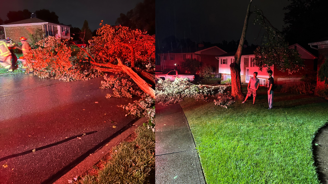
A massive power line is downed at 7600 Industrial Road in Florence, Kentucky.
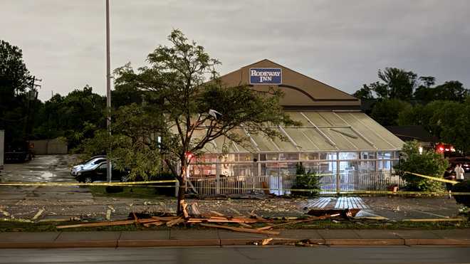
The roof of the Rodeway Inn on Dream Street in Florence was ripped off.
In southeast Indiana, a woman was rescued from her basement. She was not injured, but her house was destroyed, and power lines in the area have been reported as being downed too.
Dearborn County EMA has reported East Laughery Creek Road and Cole Lane are closed due to power line and tree damage, and will remain closed “for an extended time period.” Officials also reported one injury, but that person refused treatment.
Reports of flooding
Flooding is becoming a significant issue as severe storms move through the Cincinnati region.
I-75 northbound at I-74 near Spring Grove Avenue is shut down due to flooding along the interstate.
Multiple emergency vehicles can be seen with hazard lights blocking the roadway.
Hamilton County is under a FLASH FLOOD WARNING until 4 a.m.
A Flash Flood Warning is in effect in Ripley, Dearborn and Ohio counties until 3:15 a.m. Thursday.
Along with the severe risk, storms could repeatedly drop heavy rain over the same areas, leading to a flood risk.
Discover more from PressNewsAgency
Subscribe to get the latest posts sent to your email.