

Temperatures slowly warm up to the hottest levels this summer (so far), while relief from the drought holds for up to another week.
A slight chance of rain lingers into the evening, mainly west of I-39. Iowa showers and storms try to push into northern Illinois, but a wall of dry air overhead keeps them at bay. An isolated shower or storm could still survive, but don’t wait long for rain and the showers will be brief.

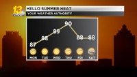
Starting Monday, temperatures rise to the upper 80s. We will see plenty of sunshine, along with dry conditions and barely perceptible humidity. By Thursday, some places may sneak into the 90s for the first time since the beginning of the month.

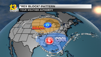
A “Rex block” pattern essentially keeps heat and sunlight in place. This pattern is hard to break, so we have consistent hot, dry weather all week. There is a chance that we will see the pattern break by the weekend, so it is possible that it will rain by the end of the week.
Discover more from PressNewsAgency
Subscribe to get the latest posts sent to your email.